

To find your way around a New York map, start with the five boroughs: Manhattan, Brooklyn, Queens, the Bronx and Staten Island. Manhattan follows a regular grid, with numbered Streets running south to north and Avenues running vertically. In practice you need three tools: a borough map for general orientation, the subway map for getting around and a points-of-interest map to decide what to see and in what order.
Table of contents
- Reading New York City From Above
- The Five Boroughs of New York at a Glance
- Getting Around Manhattan: The Street and Avenue Grid
- The New York Subway Map: Uptown, Downtown and How to Read It
- New York Map With the Main Points of Interest
- New York Neighborhoods on the Map
- Real Distances and Walking Times: Reading the Map in Minutes
- Downloading a New York Map to Use Offline
- Which New York Map to Use and When
- Travel With the Right Map
Reading New York City From Above
Seen from above, the city can feel almost intimidating: five boroughs spreading out across rivers, bridges and islands. The logic, though, is simpler than it looks, and a few minutes are enough to lock it in. Before you go, take a look at our guide on what to see in New York, so you already know which stops you will want to place once you understand how the city is laid out.
The trick is to think not of a single chart but of three layers. The first tells you where the boroughs and neighborhoods are. The second, which matters most in Manhattan, explains how the streets work. The third is the one you actually move with, by train and on foot. Let’s take them one at a time.
The Five Boroughs of New York at a Glance
New York is not only Manhattan, even if that is what you picture first. The city is made up of five boroughs: Manhattan, Brooklyn, Queens, the Bronx and Staten Island. Manhattan is the narrow, elongated island at the center, the kingdom of skyscrapers. Brooklyn and Queens occupy the western end of Long Island, east of Manhattan. The Bronx is the only borough attached to the mainland, to the north. Staten Island sits to the southwest, reached by the famous free ferry that serves up one of the best views of the Statue of Liberty.
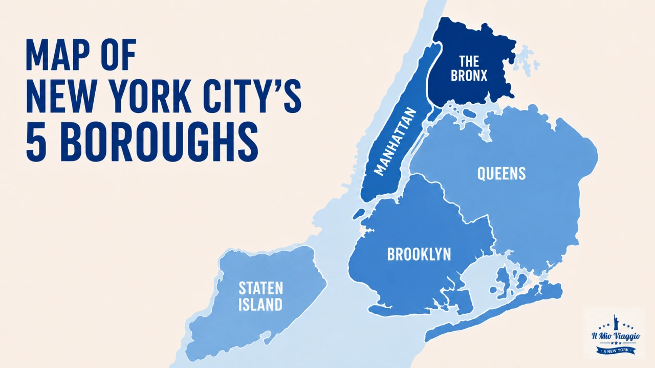
Keeping this division in mind changes how you read any New York borough map: you immediately see why two neighborhoods that look close on paper still need a bridge or a tunnel to connect them. Below you will find an interactive map you can move around freely to get a feel for how the boroughs are arranged before you even set foot in the city.
Getting Around Manhattan: The Street and Avenue Grid
Once you reach Manhattan, the map turns surprisingly orderly. Almost the entire island follows a regular grid drawn up in 1811: the Streets run horizontally, east to west, numbered in rising order as you head north. The Avenues cut across the island vertically, north to south. Knowing this pattern means never getting lost: if you know which intersection you need, you already know which way to walk.
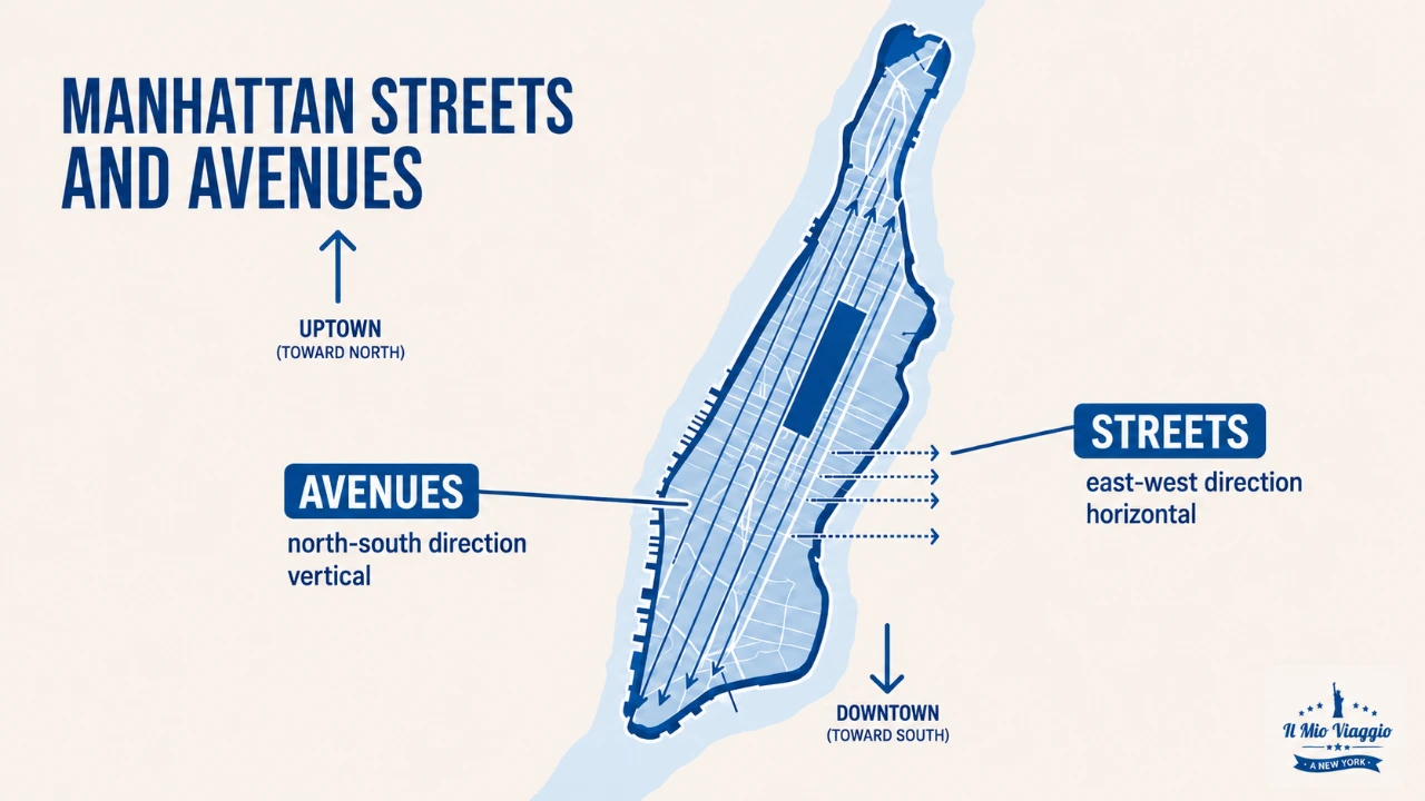
Two words will save your day: Uptown and Downtown. Uptown means toward the north, where the Street numbers climb; Downtown means toward the south, where they drop toward the financial heart of the city. One detail that catches many visitors off guard: Street addresses split into East and West starting at Fifth Avenue, so the same house number exists twice, once on each side of Fifth. Then there is one exception that breaks the rule, and it is the most famous of all.
Broadway is the only major artery that crosses the grid diagonally, because it traces an old path that predates the city. It is this diagonal that creates iconic squares like Times Square, where Broadway meets Seventh Avenue. When you spot a street cutting across everything at an angle on a Manhattan map, that is almost always Broadway.
The New York Subway Map: Uptown, Downtown and How to Read It
The subway is the fastest and cheapest way to move between boroughs, and its map is a world apart from the street map. With 472 stations running 24 hours a day, it is one of the largest networks on earth. Lines are identified by numbers and letters, each with a color: the same color groups several lines that share a stretch of track. For the practical details on getting around underground, you will find everything in our New York subway guide, which completes what you see on the map.
Manhattan Subway Stations
stations · tap a point to see the lines
The idea that confuses almost everyone is direction. On the signs and on the subway map you do not read the names of the final stops the way you might at home, but the words Uptown and Downtown, the same as on the surface. Uptown is the train heading north, Downtown the one heading south. The classic beginner mistake is catching the right train in the wrong direction: always check the direction on the platform sign before you head down the stairs.
Watch out, too, for the difference between express and local trains: locals stop at every station, while expresses skip several to move faster. On the payment side, 2026 brought a major change: a single ride costs $3.00, and as of January the MetroCard is no longer sold or refilled. Today you pay with the contactless OMNY system by tapping a card, smartphone or OMNY card at the turnstile, with an automatic weekly cap of $35 after which you ride free.
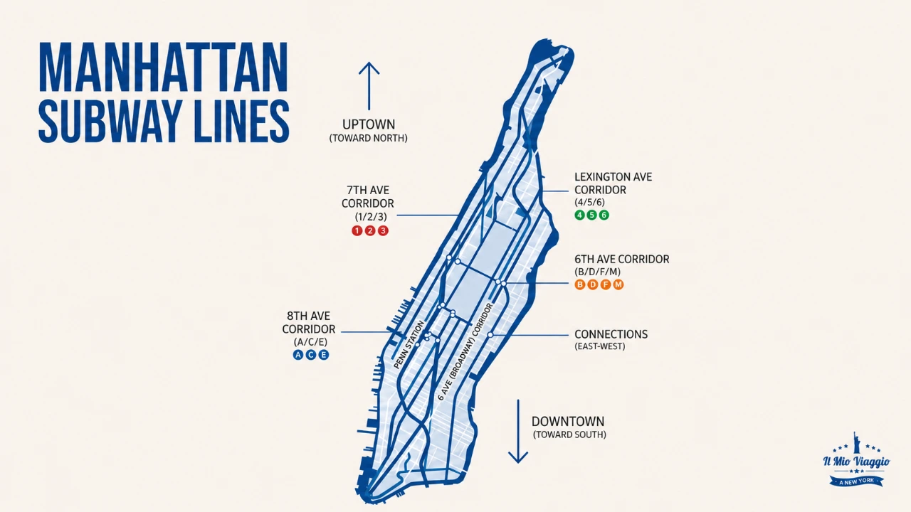
For the official network map, always updated in real time with service status, it is best to use the MTA’s live map, run by the city’s transit authority. It is free to check from your phone and also shows construction work and detours.
- Here is the official New York subway map on the MTA website
- Here is the New York subway map for late-night service
New York Map With the Main Points of Interest
Once you understand the structure of the city, the question turns practical: where are the things I want to see? That is why we put together our downloadable New York map, a digital map with all the main points of interest already marked, designed by people who live New York every day. It starts at $25 and is the easiest way to have monuments, museums and neighborhoods gathered in a single tool you can check from your phone during your visit.
Having the points of interest on one map helps above all with organizing your days by area, so you avoid crossing the city back and forth. The Empire State Building, Times Square and Rockefeller Center, for example, are all clustered in Midtown and can be visited together, while the Brooklyn Bridge and Wall Street sit to the south. When you are ready to book entry, you can do it in advance by choosing your attraction tickets so you do not waste time in line once you arrive.
New York’s Top Attractions
10 must-see spots in the Big Apple
New York Neighborhoods on the Map
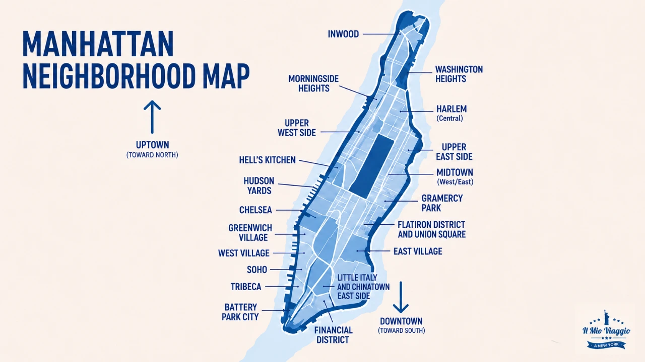
Below the level of the boroughs, the New York neighborhoods map fills with districts of strong character, each with a different soul. In Manhattan you pass within a few stops from the green of Central Park to the lights of Times Square, all the way to the narrow streets of Chinatown. Heading north you reach Harlem, the heart of African American culture and gospel, a neighborhood that deserves a visit of its own.
Crossing the East River opens up Brooklyn, the borough most loved by those after the authentic feel of the city. Williamsburg is the realm of murals, cafes and markets, with a view of the Manhattan skyline that alone is worth the trip. Placing these neighborhoods on the map shows you how much the real New York lives beyond the central island, too.
Farther north, past Manhattan, lies the Bronx, often unfairly skipped by tourists but rich in history, from Yankee Stadium to the surprising green of its parks. Keeping an eye on these boroughs too when you look at a map of New York hands you corners most visitors will never see.
Real Distances and Walking Times: Reading the Map in Minutes
Here is the thing no New York map tells you in words, but that changes every day: distances in minutes. Manhattan’s grid has a precise rhythm. Roughly 20 blocks running north to south add up to about one mile, a little over 1.6 kilometers, which means a single block between one Street and the next takes a little over a minute on foot. Knowing this lets you read the map like a stopwatch.
There is a catch, though: the east-west blocks, the ones between one Avenue and the next, are much longer than those between Streets. Crossing the city from one side to the other therefore takes more time than it looks on the map. A concrete example: from Times Square to Central Park is a few minutes north on foot, while to reach the Brooklyn Bridge you are better off taking the subway. And when you get to the park, remember it is enormous: thinking in minutes, and not just in inches on paper, is the real secret to not wasting a single hour of your trip.
Downloading a New York Map to Use Offline
The most common fear is losing your connection just as you are looking for the way. The good news is that today you can keep a New York map with you at all times, even offline. With Google Maps you can download the whole city area in advance while you are still on your hotel wifi, then navigate it with no signal and no roaming charges. Apps like Citymapper, built for city public transit, work in a similar way for the subway.
For the official subway map in printable form, you can download the PDF straight from the MTA site and keep it on your phone as a backup. And if you want a map already loaded with attractions, our digital map downloads once and stays available for your whole trip. The insider tip is simple: get everything ready before you leave, because searching for and downloading maps with your suitcase in hand and your battery at twenty percent is never a good idea.
Which New York Map to Use and When
To keep the different map types straight, here is a practical summary of which tool to use depending on the moment of your trip.
| Map type | What it is for | When to use it |
|---|---|---|
| Borough map | Understand the structure of the city and where the neighborhoods are | Before you go, to get oriented |
| Manhattan grid diagram | Read Streets, Avenues and the Uptown and Downtown directions | The first few days, while walking downtown |
| Interactive online map | Search addresses and calculate routes | Anytime, easily from your phone |
| Subway map (MTA) | Move between boroughs by train | Every time you take the subway |
| Digital points-of-interest map | Plan what to see and in what order | While planning and during your visit |
| Offline app | Find your way even without a connection | On the go, to avoid roaming |
Fares and conditions current as of May 2026. Always check the official pages for current data.
Travel With the Right Map
In the end, a New York map is not a sheet to fear but a promise: every line is a walk waiting for you, every neighborhood a story to cross. With the boroughs clear in your head, the Manhattan grid under control and the subway tamed, you are ready to experience the city like a real New Yorker and not a lost tourist. To organize every detail of your trip, from tours to attractions, start with Il Mio Viaggio a New York: the Big Apple is far more beautiful when you know exactly where you are going.
Frequently Asked Questions About the New York Map
New York is made up of five boroughs: Manhattan, Brooklyn, Queens, the Bronx and Staten Island. Manhattan is the central island of skyscrapers, while the other four spread out all around it, separated by rivers and linked by bridges, tunnels and the subway.
Manhattan follows a regular grid. The Streets run horizontally, east to west, numbered in rising order toward the north, while the Avenues run vertically, north to south. The one major exception is Broadway, which crosses the island diagonally.
Uptown points north, where the Street numbers increase. Downtown points south, toward the lower, financial part of the city. These are the terms you find on street signs and subway signs in place of the final stops.
Download the New York area on Google Maps ahead of time while you are connected, so you can navigate it with no signal. For the subway you can use dedicated apps like Citymapper, while a digital attractions map, downloaded before you leave, stays available for your whole trip.
A digital map is more convenient because it updates, works from your phone and lets you search addresses and routes on the fly. A paper map or printed PDF still makes an excellent backup to keep in your pocket, handy when your phone is dead or you have no connection.
Heading north or south, about 20 blocks add up to roughly one mile (around 1.6 km), so a single block takes a little over a minute on foot. The east-west blocks between Avenues, however, are much longer, so crossing the city takes more time.